Anyone who has lived in India knows that we waste a ton of time in giving and taking directions. I have often tried to quantify the time and whichever number I come up with, one thing is clear: the time wasted in the “last mile†directions is enormous. Just today I had someone coming to my house (and my house IMO is easy to find since it is in a neighborhood with standardized streets name setup in a nice grid) and I had to spend north of 20 minutes on giving instructions on landmarks and right/left turns at the nearest CCD etc. Given that nearly everyone has need for directions, if this wasted time could be redirected towards more productive use, I can only imagine that it will make a dent in India’s GDP.
iPhone + GoogleMaps + Where-am-I-At
Summary of how I find my way around in India:
- At any location (say home, office, restaurant), I use the app “WhereAmIAt?†to find the latitude and longitude of that location and I save that into my address book as part of notes for that contact
Let me describe how I use my iPhone to find my way around. There are two main use cases:
1) Businesses that show up on Google. This is quite straightforward, if a business (restaurant, hotel, office) is listed I can very easily find it and with the latest release of GoogleMaps I can even get directions. This works like a charm.
Finding unlisted locations such as homes, apartments, unlisted offices, unlisted restaurants etc. This is where the complication resides.
Let me explain the second use case above in detail. In the US all streets are properly named, digitized and standardized to the extent that a ZIP+4 combination actually maps to a latitude and longitude and the street address can be reconstructed back from the ZIP+4. The problem I find with the mapping and GPS solutions for India is that they are somewhat expecting this level of digitization for it to work. That’s a tall order and is a classic example of copy-pasting a first world solution in an emerging economy.
Since these have not worked for me, this is what I do for places I visit often but can’t recall exact direction (this is particularly true for me as I visit our regional offices often but since I am not familiar with the local roads, I can get lost easily; or sometimes there is a simply a language barrier with the cab driver that causes problems): I use an app called “WhereAmIAt?†to find the latitude and longitude of where I am and I store the lat/long in my address book. When I need to visit the place again I simply enter the lat/long in GoogleMaps and track my progress towards my destination.
Here is a real example of how I reach my Chennai office: I tell the cabbie to take me to Mylapore and when close, I enter the lat/long and track like this:
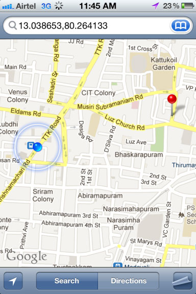
Once you have lat/long, all you need is to track progress to the destination. No need for knowing roads, landmarks etc. The lat/long can be easily shared through SMS, Email etc.
The blue marker is where I was when I took the screenshot and the red pin is where I needed to get to. This way, I don’t need to remember the road names and if we take a wrong turn I always know how to get back on track. In Chennai this is particularly useful as I don’t know Tamil and language can become a barrier when talking to the driver or asking for directions along the way. Not to mention the efficiency with which I reach my destination.
When I want to eat the most mouth watering idlis ever at Murugan Idli Shop (an unlisted local favorite in Chennai), I simply use this to get there:
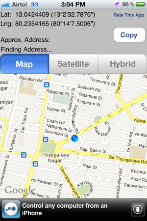
The “WhereAmIAt?†app let’s you find the lat/long of the place you are at.
So next time you want to have the same mouth watering experience, rather than saying let’s go to Murugan Idli in T.Nagar which is close to XYZ bank on the opposite side of ABC, just type in “13.0424409,80.2354165″ in GoogleMaps!
Behavioral Barriers
My observation has been that the biggest barrier to this has not been technology but behaviors. I have often tried to give directions to people by sending them the lat/long but hardly anyone seems to use it. There is just some safety in being able to call and get directions (3/4/5 times I might add) as they get closer to the destination.
However as Android phones become prolific, 3G/4G connections become standard and opportunity costs rise, I am hopeful that more and more people will use technology to at least solve this everyday problem and free up their time for more productive use.
My feature list
While it is probably best for a good product manager to flesh out the use cases, from the way that I use maps to find places, I’d like to see the following supported in GoogleMaps:
1) An ability to quickly identify where I am without the need to use another app
2) The ability to save the present location (or a dropped pin) to the address book
3) The ability to open a saved location from the address book directly on GoogleMaps
4) The ability to easily share via email, SMS, whatsapp etc a location with anyone
And here are some places one could use these features:
- Calling a cab driver home / directing an auto-rickshaw – no more multiple phone calls for directions
The list goes on. The key is that precise location can be easily communicated and followed without the need for street names, landmarks or whatever else is used to give directions.
So, GoogleMaps, ready to make a dent in India’s GDP?
This article is reproduced with permission of Dheeraj Kacker. He tweets @dhirajkacker
(Dhiraj Kacker is CEO & Co-founder of Canvera.com, an online Digital Photography company based out of Bangalore.)
To become a guest contributor with VCCircle, write to shrija@vccircle.com.